 |
| Geomorphology of Barito River |
Topan Ramadhan1,Shandy H.W1, Eka Fajar.N.S1, Nico Okto W.H1
1Geological Engineering, Faculty of Mineral Technology – Institut Sains & Teknologi AKPRIND Yogyakarta
ABSTRAK
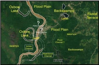
The study area is located in the Buntok town which is administratively a capital Dusun Selatan district as well the capital of South Barito regency, Central Kalimantan Province. Flooding always being yearly problematic disaster significantly happens, this has an impact on social aspects, but particularly impact on infrastructure development problems. Geological investigations should be conducted by means of geological mapping with analysis of geomorphology and hydrology as well. Based on the investigation it was found that the Buntok town is situated by young sediment fraction predominantly fine grain. In addition, from the manual analysis of coring obtained multiple layers that show the ancient flood sediment. Geomorphological analysis shows the city area Buntok is situated in the Flood Plain landform unit on Barito drainage basin (DAS) with an average elevation of 1-2 meters above sea level. As well as on the analysis of aerial photographs shows the presence of ancient Barito river flow patterns that head to giving area. Based on a series of investigations it is known that the study area is currently included in the flood-prone area with high intensity that the relocation of the urban area to a safer area is assumedly needed.
Keyword: study environmental geology, flood disaster mitigation, buntok town, barito drainage basin

